AUTHORS
Rosny Jean1, Justin St. Juliana2, and Nancy Nthiga1
1School of the Environment, Florida Agricultural and Mechanical University, Tallahassee, FL 32307
2Department of Ecology and Evolutionary Biology, Cornell University, Ithaca, NY 14853
Corresponding author: Rosny Jean (rosny.jean@famu.edu)
THE ECOLOGICAL QUESTION
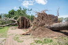
Extreme weather events, such as tornadoes, can cause rapid and widespread disruption to ecosystems, with tree canopy loss being one of the most immediate and ecologically significant effects. The May 10, 2024, tornado outbreak in North Florida included two EF-2 tornadoes that converged over Tallahassee, providing a clear, real-world case study of these impacts. Canopy reduction affects biodiversity, limits carbon sequestration, and disrupts ecosystem functions, while increasing sensitivity to future climate extremes. Assessing the extent of this disturbance is essential for understanding ecological consequences and informing restoration efforts. This case study employs remote sensing in ecological research, providing an efficient way to monitor landscape changes across large areas. By comparing satellite data from before and after the tornado, students can explore how such events reshape ecosystems and better understand the role of forests in climate resilience. This figure set provides visual insight into canopy loss, helping students analyze spatial and temporal patterns while considering broader ecological implications.
FOUR-DIMENSIONAL ECOLOGY EDUCATION (4DEE) FRAMEWORK
- Core Ecological Concepts:
- Landscapes
- Ecosystems
- Ecology Practices:
- Designing, conducting, and critiquing investigations
- Quantitative reasoning and computational thinking
- Data analysis and interpretation
- Human-Environment Interactions:
- Human impacts on the environment from local to global scales
- Cross-cutting Themes:
- Space & Time
Integration across 4DEE Dimensions
Understanding the ecological impacts of severe weather events like tornadoes requires an integrative approach that incorporates multiple dimensions of ecological education. This dataset and associated activities foster integration across the four dimensions of the 4DEE framework:
- Core Ecological Concepts & Ecology Practices:
- Students engage with the concepts of disturbance and recovery by analyzing how tornadoes impact tree canopy cover and the subsequent ecological consequences.
- The activity involves quantitative reasoning and computational thinking through remote sensing and geospatial analysis, allowing students to measure and visualize spatial and temporal changes in canopy cover.
- Ecology Practices & Human-Environment Interactions:
- The integration of remote sensing and geospatial analysis equips students with tools to assess environmental change, an essential skill for applied ecological research and disaster response.
- Cross-cutting Themes & Core Ecological Concepts & Human Environment Interactions
- The spatial and temporal nature of tornado impacts is central to the dataset, allowing students to examine landscape-scale changes over time, and how they impact people.
WHAT STUDENTS DO
Students work with remote sensing data and geospatial analysis tools to quantify and visualize the impacts of tornadoes on tree canopy cover. They:
- Utilize Google Earth Engine software to map spatial changes in forest cover.
- Conduct quantitative analysis on the extent of disturbance and recovery patterns.
- Interpret results and discuss implications for ecosystem services and climate resilience.
- Engage in verbal class discussions on ecological restoration and human-environment interactions related to severe weather events.
STUDENT-ACTIVE APPROACHES
Think-pair-share, hands-on image analysis, designing experiments to assess ecological impacts, using remote sensing software tools (i.e. Google Earth Engine), and exploring computational methods for change detection in forested landscapes.
STUDENT ASSESSMENTS
Answering questions on a worksheet, sharing interpretations of pre- and post-event data with the class, creating classification maps, performing Normalized Difference Vegetation Index (NDVI) and change detection, as well as answering questions about ecological disturbances.
CLASS TIME
This Data Set is designed to span one 75-minute class or split over two 50-minute class sessions.
COURSE CONTEXT
This Data Set is recommended as part of advanced courses in environmental science, ecology, geography, or remote sensing at undergraduate and graduate levels.
SOURCES
- North Florida Shapefile: FWC (Florida Fish and Wildlife Conservation Commission) https://geodata.myfwc.com/datasets/myfwc::fwc-regions/about
- Software used: Google Earth Engine, which offers free access to all users without license restrictions (https://code.earthengine.google.com/)
DOWNLOADS
Description of resource files
- Video tutorial [Tornado Project video.mp4]
Data sets for students include:
- Shapefile of North Florida [zip]
Data sets for faculty include:
- Shapefile of North Florida [zip]
- Landsat 9 imagery for North Florida [png]
- Sentinel-2 imagery for North Florida [png]
- NDVI before the tornado using Landsat 9 imagery [png]
- NDVI after the tornado using Landsat 9 imagery [png]
- NDVI Change map after the tornado using Sentinel-2 imagery [png]
- NDVI before the tornado using Sentinel-2 imagery [png]
- NDVI after the tornado using Sentinel-2 imagery [png]
- NDVI Change map after the tornado using Sentinel-2 imagery [png]
ACKNOWLEDGMENTS
The authors acknowledge the use of Google Earth Engine for data access and analysis. Special thanks are extended to Christopher Beck and the anonymous reviewers for their thoughtful reviews and constructive comments, which helped strengthen this work. The authors also acknowledge the School of the Environment at Florida A&M University and the Department of Ecology and Evolutionary Biology at Cornell University for their institutional support.
CITATION
Rosny Jean, Justin St. Juliana, and Nancy Nthiga. December 2025. Satellite-Based Assessment of Tree Canopy Disturbance from the May 2024 Tornado in North Florida Using Google Earth Engine. Teaching Issues and Experiments in Ecology, Vol. 21: Practice #1. https://tiee.esa.org/vol/v21/issues/data_sets/jean/abstract.html